www.map.statistics.gov.lk

Population and Housing Census Map Portal


Responsive Image

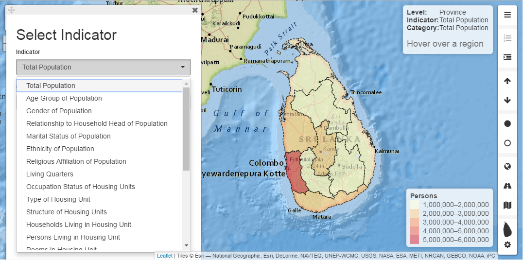
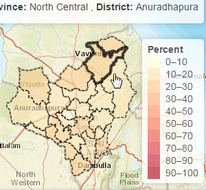
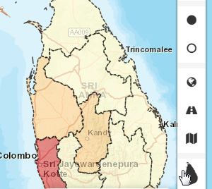
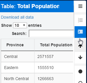
Population and Housing map is a map portal which interactively display Population and Housing information collected in the Sri Lanka Census of Population and Housing - 2012 (CPH 2012) in thematic maps as well as table formats at Province, District, Divisional Secretariat and Grama Niladhari Division levels. This census map portal could display Street map, Saterllite and National Geographic map as the base layers to facilitate comparison between geographical and builtup information with the census collected data.

User guide: How to ...

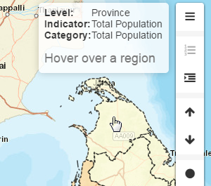
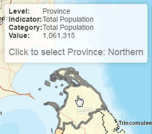
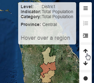
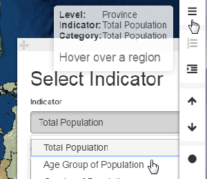
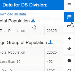
The message as well as a status box located at the top-right hand side corner of the map portal provides quick help instructions, information related to the area and administrative level currently focused at as well as the selected data values of the selected area interactively and is always on display. Additionally the following graphics and texts formally explain how to get a specific task done within Population and Housing map portal and answers to FAQs.

Understand the initial View


The Population and Housing Map Portal starts with a complete aerial view of Sri Lanka map and allows to identify provinces by just moving mouse over the provinces. The initial display also shows the thematic map of province level population with the Legend related to it and the exact population figures are shown in a fixed indicator box at top right-hand side corner of the map box.

The menu bar of the map portal is vertically located as a Tool bar at the extreme right side of the map and it panels all the user functionalities of the system.


Select an Administrative Level


To select an administrative area at a level below the Province level the required province or the province in which required district or Divisional Secretary Division (DSD) or Grama Niladhari Division (GND) is located should be selected first by clicking inside the desired province on the initial or provincial map view. Then the whole system is focused to the selected province and data belongs to the selected province and the districts in it are loaded. Similar selections are required to display Districts, DSDs and GNDs within the selected areas and to get the system focused to the area about which the census information is needed.


Select a Lower Administrative Level


To select a lower administrative area at a level below the current level the area in the current level in which the required lower level area is situated should be selected by clicking inside the desired area. Then the system focuses to the selected area and one more selection is required to display lower level areas included within the selected area and so on.


Moving to the Lower or Upper level using Tool bar


To select or move to a lower administrative area at a level below the current level the area in the current level in which the required lower level area is situated should be selected by clicking inside the desired area. Then the system focuses to the selected area and one more selection is required to display lower level areas included within the selected area and so on.

The figure displayed left shows the buttons with up and down arrow Icons located in the tool bar which also performs the moving to upper or lower levels between Province and DSD levels across the District level with a single click of the respective button.

To go to the level just below the current level using the down arrow button, an area from the current level should be selected first as instructed in the message box always on display at top-right hand side corner of the map portal. Obviously, moving to the upper level need not to select an area as every repeated click of the upper arrow button moves the focus to the area one level above the current level till the country-wide province level is met.


Display country wide or area specific thematic map


Population and Housing Census map portal could display all the administrative areas listed in the country of the selected administration level in one thematic map view with country -wide data or only a selected area thematic map with data in it. The Sri Lanka icon at the bottom of the menu bar as the figure shows toggles this feature. The province view always shows the entire number of provinces and all the other level selections show only the selected area first where selection of the country icon once is needed to get the country-wide thematic map view displayed.

Please note that at Grama Niladhari Division (GND) level only one Divisional secretariat division could be displayed at a time. However the data of the entire GNDs are shown in the table view from which data down loads in coma separated format could also be accomplished.


Select a census variable and category


The Census map portal could display all the important census information collected at Grama Niladhari Level in thematic maps as well as in table formats. To change the census variable which uses to draw the thematic map the variable or indicator selector box, which is on display at the bottom left corner of the portal at the initial view and includes with 2 combo boxes should be used. The first combo box allows to select a variable and once a variable was selected the categories or values in the selected variable are displayed and allowed to be selected in the second combo.

The variable selector panel can be removed from display by simply closing it and alternatively the first button in the tool bar could also be used to on and off the display and bring the panel back when it is out of display


Display and download all the data tables of the selected region


The Census map portal optionally displays all the important census information collected at Grama Niladhari Division Level at least in table formats and the table with all the data related to the selected region could be displayed using the second button named All data of the area in the tool bar menu. The data downloading option is displayed at the top of the list as well as on top of each table to get all the data tables at ones or get a selected table downloaded respectively in .csv format.


Display and download all the data for selected table


The Census map portal optionally display all the important census information collected at Grama Niladhari Level at least in table formats as well and the table with all the data related to the selected table with all the regions of the level could be displayed using the third button named All data of the table in the tool bar menu. The data downloading option is displayed at the top of the table to down load the data table in .csv format.


Developed by Department of Census and Statistics - Sri Lanka
Copyright  2017 DCS, Sri Lanka, All Rights Reserved